Weather VSI
Weather
Types of Cloud
| Prefix\suffix | Cirrus | Cumulus | Nimbus | Stratus |
|---|---|---|---|---|
| Alto | Altocumulus | Altostratus | ||
| Cirro | Cirrus | Cirrocumulus | Cirrostratus | |
| Cumulo | Cumulus | Cumulonimbus | ||
| Nimbo | Nimbostratus | |||
| Strato | Stratocumulus | Stratus |
Stem Definitions
- alto
-
high
- cirro/us
-
ringlet or curling lock of hair; curl-like tuft, fringe, or filament.
- cumulo/us
-
heap, pile; an accumulation, gathering; the conical top of a heaped measure
- nimbo/us
-
rain-bearing
- strato/us
-
spread out or layered; a quantity of a substance or material spread or laid over a surface, esp. horizontally, to a more or less uniform thickness; a thin layer or coating; esp. each of two or more parallel layers placed successively one upon another.
The endings “o” and “us” in cloud names are related to their Latin origins and are used to create compound words that describe cloud types. “o” is often used as a linking vowel to smoothly connect two Latin words or word elements, especially when the second word or element starts with a consonant. “us” is a common Latin noun ending, particularly for masculine nouns in the nominative singular.
Genera
- altostratus
-
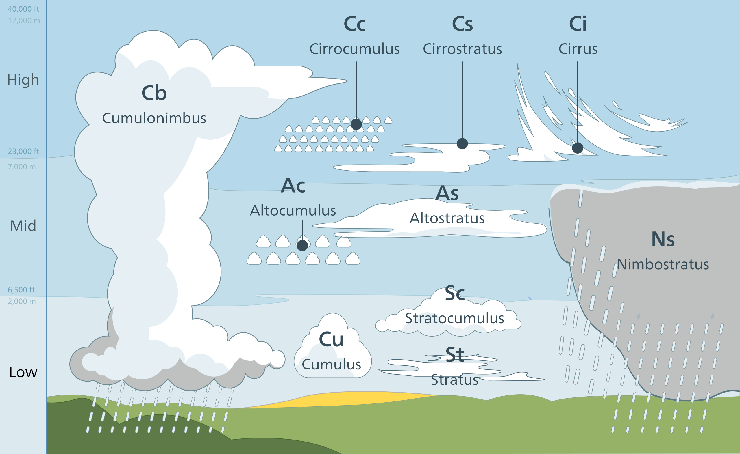
Cloud forming a continuous uniform layer which resembles stratus but occurs at medium altitude (typically 6,500 to 23,000 ft, 2 to 7 km).
- altocumulus
-
Cloud forming a layer of rounded masses with a level base, occurring at medium altitude (typically 6,500 to 23,000 ft, 2 to 7 km)
- cumulus
-
One of the simple forms of clouds, consisting of rounded masses heaped upon each other and resting on a nearly horizontal base. Frequent in the summer sky, where it often presents the appearance of snowy mountain-masses.
- cirrocumulus
-
A form of cloud combining the shapes of the cirrus and cumulus and consisting mainly of a series of roundish and fleecy cloudlets in contact with one another.
- cumulonimbus
-
the thunder-cloud. It frequently takes the form of towers or anvils.
- stratus
-
cloud type characterized by a broad low horizontal sheet of nearly uniform thickness, usually found at low elevations; a cloud or fog bank of this type.
- stratocumulus
-
a type of cloud of an intermediate type between stratus (which they most resemble) and cumulus
- nimbostratus
-
A rain cloud forming a horizontal layer; spec. †(a) (P. Weilbach’s name for) a form of cloud consisting of horizontally massed cumulus clouds associated with squally rainfall (obsolete); (b) a form of cloud occurring as a thick, low, extensive layer, which is grey and often dark, and from which rain, sleet, or snow falls (not necessarily reaching the ground) unaccompanied by lightning, hail, or thunder.
- cirrus
-
A form of cloud, generally at a high elevation, presenting the appearance of diverging filaments or wisps, often resembling a curl or lock of hair or wool.
- cirrostratus
-
A form of cloud combining the shapes of the cirrus and stratus, consisting of horizontal or inclined sheets attenuated upwards into light cirri.
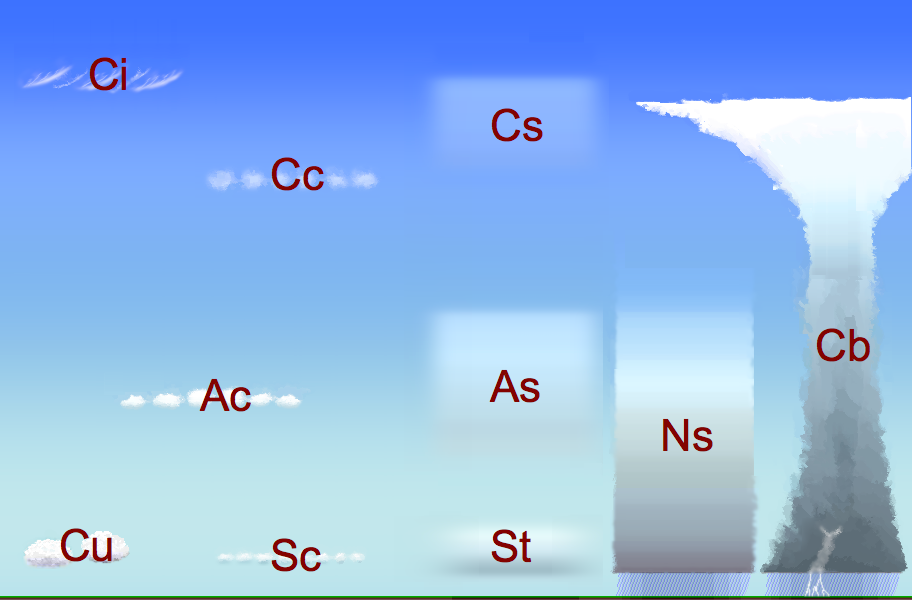
- Altostratus and Altocumulus are mid-level clouds.
- Cumulus, Cumulonimbus, and Cirrocumulus are cumuliform clouds, with Cumulonimbus being capable of significant vertical development and associated with severe weather.
- Stratus, Stratocumulus, and Nimbostratus are types of low-level stratus clouds, with Nimbostratus being a thick layer capable of producing prolonged precipitation.
- Cirrus and Cirrostratus are high-level clouds, with Cirrostratus often forming a thin veil that can cover the sky.
Here are the 10 basic types of clouds, their etymologies, and some of their properties:
Cirrus (Ci) - Derived from the Latin word ‘cirrus’ meaning a ringlet or curling lock of hair. These are high-altitude clouds, typically above 6,000 meters, thin, and wispy. They do not produce rain.
Cirrostratus (Cs) - Combines ‘cirrus’ with ‘stratus,’ the latter from Latin meaning ‘spread out’ or ‘layered.’ These clouds form a high, thin layer that can cover the sky, often giving it a milky appearance. They are found above 6,000 meters and can produce halo phenomena but not precipitation.
Cirrocumulus (Cc) - A blend of ‘cirrus’ and ‘cumulus’ (from Latin ‘cumulo,’ meaning heap or pile). These are small, white patches of clouds at high altitudes (above 6,000 meters), usually not producing precipitation.
Altostratus (As) - ‘Alto’ from the Latin for ‘high’ combined with ‘stratus.’ These are mid-level clouds, generally found between 2,000 and 7,000 meters, forming a grey or blue-grey layer that often covers the sky, possibly leading to light precipitation.
Altocumulus (Ac) - Combining ‘alto’ and ‘cumulus,’ these mid-level clouds, ranging from 2,000 to 7,000 meters, appear as white or gray layers or patches with shading. They usually don’t produce significant precipitation but can indicate changes in the weather.
Stratus (St) - From the Latin ‘stratus,’ meaning spread out or layered. These are low-level clouds, below 2,000 meters, forming a uniform grey to white layer that can cover the entire sky, resembling fog that doesn’t reach the ground. Light mist or drizzle can occur.
Stratocumulus (Sc) - A mix of ‘stratus’ and ‘cumulus.’ These low-level clouds, found below 2,000 meters, are large, dark, rounded masses, often in groups, lines, or waves. They may produce light rain but are typically non-precipitating.
Nimbostratus (Ns) - ‘Nimbo’ is derived from the Latin ‘nimbus,’ meaning rain-bearing, combined with ‘stratus.’ These are thick, dark, low to mid-level clouds, typically below 3,000 meters, covering the sky and associated with continuous rain or snow.
Cumulus (Cu) - From the Latin ‘cumulo,’ indicating heap or pile. These are low-level clouds, generally below 2,000 meters, with noticeable vertical development and a flat base, resembling cotton. They can develop into larger storm clouds but on their own, usually do not produce precipitation.
Cumulonimbus (Cb) - Combines ‘cumulus’ and ‘nimbus,’ indicating a cumulus cloud capable of producing thunderstorms. These towering clouds can extend high into the atmosphere, crossing various altitude levels, and are associated with heavy rain, thunderstorms, and extreme weather like hail and tornadoes.
These cloud types are part of the classification system based on their appearance and altitude, helping in the understanding and forecasting of weather patterns.
Deets
- Storm (!) Dunlop
- Volume 506
- Published 2017


